Report-a-Weed
Online Invasive Plant Reporting
-
Publications,
Downloads and
Resources- Weed Identification Software - easy to use, inexpensive software that lets you identify 1,200 plant species in the US and Canada. No complicated scientific lingo - can be used by anyone.
- 2011 Wall Calendar - features a different invasive plant species as a backdrop for every month. Also displays a map with the names and contact info for the Regional Weed Committees in BC. [size: 28in x 36in; 14MB]
- 2011 Monthly Planner - intended for double-sided printing on 8.5 X 11 paper. Punch 3 holes and put in a binder. Looks best in colour! [pdf, 15 MB]
- Coastal Weeds Poster - features 50 invasive species, sorted by 'open terrestrial', 'wetland', and 'below canopy' habitat preferences. [size: 28in x 36in; very large file 67 MB]

- BC Invasive Plant Strategy
- Invasive Plant legislation - webpage with links to the BC Weed Control Act, Community Charter, Pipeline Act, Plant Protection Act, Seeds Act, and the Legislative Guidebook to Invasive Plant Management in BC.
-
Invasive Plants
British Columbia
- BC Inter-Ministry Invasive Species Working Group - IMISWG
- BC Ministry of Forests, Lands and Natural Resource Operations - Invasive Plants Home
- Royal BC Museum
- E-Flora BC - On-line encyclopedia of native, alien, and invasive plants in BC.
- Weeds BC
- BC Field Guide to Noxious & Other Selected Invasive Plants of BC
- BC Species and Ecosystems Explorer - Conservation information on 6000 plants and animals.
- Integrated Vegetation Management Association of BC (IVMA) - Professional organization dedicated to the responsible practice of all aspects of vegetation management.
- Invasive Plants of Southwestern BC - Focus is on a limited number of Coastal BC invasive plant species.
The Invasive Species Council of BC - Start on their Plant Watch page. 
Canada
- Canada's Online Weed Information and Identification Resource - Illustrated Weeds Database - Agriculture and Agrifood Canada.
- Canadian Food Inspection Agency Invasive Plants in Canada - Summary Report.
- NatureServe Explorer -'An On-Line Encyclopedia of Life' Flora, Fauna, and ecosystems of the United States and Canada. Includes in-depth coverage for rare and endangered species.
- Evergreen - Features a native plants database.
- Hinterland Who's Who - Invasive Alien Species in Canada
Outside Canada
- Invasive Plant Atlas of the United States
- Plants Database - Standardized information about the vascular plants, mosses, liverworts, hornworts, and lichens of the U.S. and its territories.
- National Invasive Species Information Center
- Centre for Invasive Plant Management
- US Forest Service
- Invasive Plants Manuals database for downloadable, illustrated pdf documents. - US Dept. of Agriculture - Invasive Plants Image Gallery & Database.
- US Dept. of Agriculture - Agricultural Research Service - Highly technical, scientific taxonomy data for plants. Has search feature, and many links to other scientific research sites.
- The Nature Conservancy
- Weed Science Society of America
- Dave's Garden - US Plants database; includes insect database & terminology.
- Nature Conservancy's iMap Invasives - US Invasive Plant Gallery and Database.
- University of Montana-Missoula - Invaders Database System - focuses on five states in the Northwestern United States.
- Invasipedia - Invasive plants, animals, and pathogens, and how to best manage them.
- Global Compendium of Weeds - Extensive plant list (28,000+ plants).
-
Invasive Plant/Species
Committees in BCContact the Invasive Plant/Species Committee in your area for information, educational materials, field days and other activities.
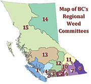
Download this map with additional contact information - 1. Coastal Invasive Plant Committee - Covers the geographic areas of Vancouver Island, the Gulf Islands and the Regional Districts of Powell River, Strathcona, and Mount Waddington on the Mainland Coast.
- 2. Greater Vancouver Invasive Plant Council - Covers all lands within the Metro Vancouver Regional District.
- 3. Fraser Valley Invasive Plant Council - Covers the boundaries inclusive in the Fraser Valley Regional District, from east of Hope to west of Abbotsford/Mission, and north to Skatin and Lil’wat territory.
- 4. Sea to Sky Invasive Species Council - Covers all lands in the Sea to Sky Corridor from Lions Bay to height of land on the Duffy Lake Road (Hwy 99).
- 5. South Okanagan Similkameen Invasive Plant Society - Covers all lands within the Regional District Okanagan-Similkameen (RDOS), including the municipalities of Summerland, Penticton, Oliver, Osoyoos, Keremeos and Princeton.
- 6. Boundary Weed Management Committee - Covers all lands within the Kettle River Drainage; the Boundary portion of the Regional District of Kootenay Boundary.
- 7. Central Kootenay Invasive Plant Committee - Covers the Central Kootenay Regional District and areas A & B of the Kootenay Boundary Regional District from the Paulson Summit East.
- 8. East Kootenay Invasive Plant Committee - Covers all land within the Regional District of East Kootenay (approximately 26,000 km2).
- 9. Central Okanagan Regional District (CORD)There is no invasive plant committee in the Central Okanagan. Please direct inquiries to CORD.
- 10. North Okanagan Regional District (NORD) -There is no invasive plant committee in the North Okanagan. Please direct inquiries to NORD.
- 11. Columbia-Shuswap Regional District (CSRD) - There is no invasive plant committee for the Columbia-Shuswap. Please direct inquiries to CSRD.
- 12. Southern Interior Weed Management Committee - Covers the Thompson-Nicola Regional District, with an area of 45,279 square kilometers. Includes ten municipalities (Ashcroft, Barriere, Cache Creek, Chase, Clearwater, Clinton, Kamloops, Logan Lake, Lytton and Merritt) as well as ten electoral areas.
- 13. Cariboo Chilcotin Coast Invasive Plant Committee - Covers the Cariboo Regional District and the Central Coast Regional District. This ranges from Hixon north of Quesnel, south to 70 Mile House, east to Wells Grey Park, and west to the Pacific Ocean.
- 14. North-East Invasive Plant Committee Fort Nelson Invasive Plant Management Committee - The NEIPC covers all areas of the Peace River Regional District. The FNIPMC covers all areas within the Northern Rockies RegionalMunicipality boundary and is approximately 85,000 square km.
- 15. North-West Invasive Plant Council - Covers four regional districts: Bulkley-Nechako, Fraser Fort George, Kitimat-Stikine, and Skeena Queen Charlotte; the Stikine Region adjacent to the Yukon border, and all municipalities within these regions.